


IN THE ARMS OF MAGURA SISKA
Opis produktu
TYPE OF THE ROUTE: cycling
LENGTH OF THE ROUTE: approximately 34 km
THE ROUTE: Osturňa – Ždiar – Bachledova Valley – Furmanec (1038 above sea level) – Veľká Franková – Osturňa
THE HEIGHT PROFILE:
DESCRIPTION OF THE ROUTE: The route starts in Osturňa, where we can get to know the rich folklore life of the inhabitants, because about 157 objects are listed in the list of monuments. From the centre of the village we go up to the crossroads and along the green bicycle trail we go via the asphalt road in the direction of Ždiar. The road leads up the hill, after further turns through the forest we reach the main ridge of the Spišská Magura. Descending down on the left side you will have a beautiful view of the Belianske Tatras with the highest Havring (2152 m above sea level) at the head. In the past it was possible to ascend the yellow trail to Havran from Ždiar, but nowadays it is not possible to enter, because the whole massif is located within the boundaries of the strict reserve. To the left of Havran we have Nowy Wierch (1999 m above sea level) and to the west of it we have the last peak of the Belianske Tatras - Murañ (1890 m above sea level), which has been known to highlanders for a long time. In the nineteenth century where the number of sheep grazed in the Tatra Mountains was already huge, a small grassy flattening, were used like Jagnięcia Zagroda (1625-1850 m) at a Murań. Highlanders from Jurgów carried lambs on their backs and left them there throughout the summer grazing period. We get to the main road and turn left towards the bottom, passing fields on the way, where sheep graze up to this day. At the ski lift, Ždiar Strednica, turn left down to Ždiar. On the spot we can visit the Ždiarsky House Museum, where we will learn about folklore and the life of people in the Belianske Tatras. The museum offers everyone a possibility to dress in typical folk costumes and it is possible to take part in the ritual of “Ždiarský wedding”.
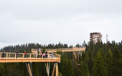
From Ždiar in the direction of Spišská Bela, after 3 km, we turn left to the Bachledka ski resort in Bachledova Valley. There you can choose between two options, either use the ski lift and go to the top or use the yellow cycling path number 8863 to climb on your own feet. After reaching the summit we can take advantage of the new attraction offered by the Crowns of the Trees Walk - it is a viewing platform built above the tops of trees, with a large observation tower, from which we can then slide down the slide.
We follow the yellow bicycle trail number 8863 to the northeast, go through the peak of Furmanec (1038 m above sea level) and go north leaving the ridge behind. After about 1 km our bicycle path turns right onto the slope, which leads to the other side of the valley. Leaving the forest via the dirt road we head along the forest to the road that goes from Hanuszowce. We turn left and follow the green cycling trail no. 5865 to Veľká Franková.
Veľká Franková, like Osturňa, is inhabited by people of Lemko origin. To this day, the locals have preserved their folklore and the original language, which is not understood even by Slovaks. A lot of old wooden log buildings with gaps between beams, boarded up, usually painted in blue have been preserved here. The route ends when you reach Osturň.
Dodatkowe informacje